New technologies are restoring the trust between producers and insurance companies
Hail, spring frost, storms and floods are happening suddenly and devastating the yields, which is why farmers are choosing to insure their crops. Damage assessment is often very subjective and opinions of farmers and representatives of insurance companies are known to differ drastically. This discrepancy leads to the lack of mutual trust, scepticism and a very small number of insured fields, as we are witnessing today in Serbia. Fortunately for both sides, new technologies are allowing us to analyse the state of the crops in a timely and objective manner and give estimates based on the facts.
BioSense is one of the leading institutions in the field of remote sensing and crop monitoring and our research has been recognised worldwide. Crop classification and monitoring systems are something we have been working on even before Copernicus programme of European Space Agency, and now, with Sentinel satellites, we have a unique opportunity to monitor the crop growth from space every 5 days on a 10 m resolution. Satellite vegetation indices are excellent proxies for plants’ needs for water and nutrients and clear indicators of their “health status”. NDVI, EVI, NDMI and other indices are allowing us to pinpoint the regions inside the field that have been affected by fire or extreme weather events, and only by analysing them all together we are able to get a comprehensive overview of the state of crops. Advanced machine learning methods are trained on images from historical datasets and calibrated to recognise changes in crop status within time-series of satellite images. Algorithms developed in this way can differentiate between normal changes happening during the growing season and changes that happened due to fire or extreme weather events. In the next step, pixels are automatically counted and their area is summed up, giving rise to an objective system for assessment of damage intensity and affected area.
Unobjective damage assessment is still not the only reason for disputes between farmers and insurance companies. The problem often occurs during the creation of the contract. The lack of information regarding the cadastral ID of the parcel, its boundary and area, can lead to future disagreements and this topic is, as a rule, dealt with only after the damage occurs. The solution for this lies in AgroSense. The platform of digital agriculture of Serbia has a clear and simple system for parcel selection from the cadastre or its mapping, which allows for automatic boundary definition and area calculation. With user consent, the access to these data is granted to the insurance company as well and both sides are getting satellite images for monitoring the growth of crops and possible damages. This system contributes a great deal to fair trade, objective determination of premiums and claims and restores trust between farmers and insurance companies.
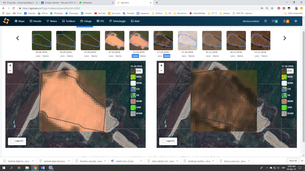
The image illustrates the application of satellite module of AgroSense in damage assessment. Satellite images from two dates are shown, one before, and one after the fire. Crop residues are seen on the left in sandy brown, while after the fire they turned dark brown, as seen on the right.